The extreme heat and lack of precipitation in B.C. is not only causing wildfires, it is also playing havoc with rivers and wildlife.
The provincial government has announced a level three drought rating for the region and taken the additional action of suspending fishing in streams and rivers in the area starting July 15.
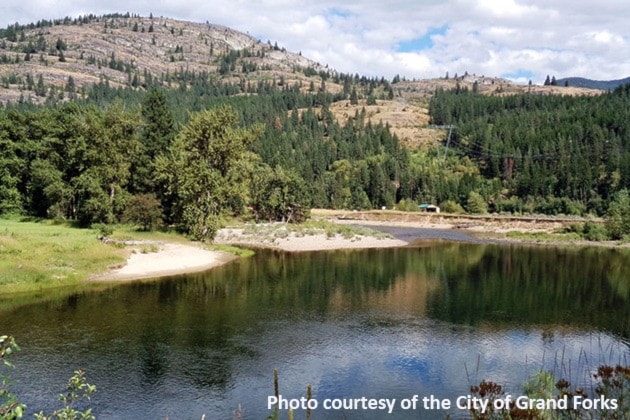
The Kettle River is at its all-time low near Midway, while at Laurier (near the Cascade border crossing) it is just above the all-time low there from 1934.
The Kettle River at Laurier was measured on Friday at 27 cubic metres/second (cm/s). The record low was 24.18 cm/s in 1934. The average volume is 97 cm/s.
The Kettle River at Ferry, Washington, just by Midway, was measured Friday at 10 cm/s, which is the all-time low. The previous record was 11 cm/s in 1934. The average volume is 50 cm/s in that spot.
The Granby River is down to 5.69 cm/s, which is more than three cm/s lower than the minimum for this time of year. All above measurements have been done by the United States Geological Survey.
Water Survey of Canada measured the Granby River. which is currently at an all-time low of 5.1 cm/s. The previous record low was 7.3 cm/s for July 10. Water Survey of Canada only measures the Kettle near Westbridge, which is measuring 5.4 cm/s.
Graham Watt, chair of the Kettle River Watershed Project, said that the weather is the biggest factor in the river levels.
“Over the winter we had a really low snowpack,” he said. “We had some rain on snow that melted things quite rapidly. Back in February it was wet and things melted. It got warm and the river came up to April levels in February. At that point I was getting a little worried about what was to come.”
Watt said there was another pulse in March that was similar to May flows.
“There was a couple of small peaks and then it declined quite rapidly,” he said. “By June we were seeing July-type flows. And now we’re seeing August-type flows and certainly August-type temperatures in the water.”
Watt said the biggest cause has been the warm winter, the early snowmelt and the really, really warm and dry spring and early summer.
“The record warm June is just a great indicator of what happens in a warm year,” he said.
Watt says there are other complicating factors affecting the river levels such as land use and forestry.
“The other big factor, of course, is water use,” he said. “In a really dry period like this summer, we would collectively as water users be using more water than is flowing in the river itself.”
Watt said the reason the river doesn’t completely run dry is that users are drawing from the ground water and that provides a buffer.
“Because it’s not pulling directly from a stream in a lot of the cases the impact is slightly buffered and there’s a bit of time before it reaches the river,” he said. “Water use gets really important as the water levels get low. The decisions people make about using water in May, June, July may affect river conditions in August, September because of that lag.”
Watt said it’s important in a situation like Grand Forks to have water conservation so that there is enough pressure in the system to run the fire hydrants and keep the reservoir levels at a decent level.
Grand Forks has a very good aquifer that is fed by the rivers as well as nearby streams and mountainside run-off, Watt said.
“When the city takes water from the ground, it can lower the water table. It can make the water flow towards the wells from the river instead of towards the river from the water table. In the valley, there have been some cases seen where the wells can create a pulling away from the river. So the river is essentially feeding the ground water rather than the ground water feeding the river. So it’s a reversal.”
Watt said that that only becomes important during low-flow periods.
“Most of the time we have lots of water in the aquifer and we’re not going to be running out but that kind of gives people a false sense of security; a false sense of abundance,” he said. “It’s an excellent aquifer with lots of water, that’s true, but when you look at the fact that it’s also feeding the river and the river feeds it, it can affect river health for sure.
“In a summer like this if we don’t have a lot of rain, which usually doesn’t happen in July anyway, and if people continue using water at the present rate, I expect we’ll see record low flows and a really long, very dry period where the river is barely a trickle and people won’t even be tubing much at all.”
Another concerning issue is the high temperature of the rivers, which is causing great stress for fish.
“The thing that worries me the most right now is temperature,” said Watt. “The river is so warm that fish are dying. Mountain white fish, rainbow trout and even speckled dace, which are usually very resilient to warmer temperatures. They don’t like it when the temperature of the water gets into the mid-20s. It affects their metabolism and the amount of oxygen in the water. Water can’t hold as much oxygen when it’s warm. The fish basically are not quite suffocating but they get so stressed out they die.”
Watt says he has heard from places from as far as Westbridge right to Christina Lake about fish dying.
Tara White, a fisheries biologist for the Ministry of Forests, Lands and Natural Resource Operations, has been in the Boundary region looking at the situation with the fish and the rivers.
Watt said it’s unfortunate is that the area does not have a coordinated drought response and that’s one of the biggest things that needs to change.
“We need to get all water suppliers, the province and water stakeholders working together to make a coordinated drought response before we are in an emergency situation,” said Watt.
The Okanagan-Kettle area of B.C., which includes Grand Forks and the Boundary, has been classified as a level three drought region. Level three is the second highest and means very dry conditions. The province’s drought level classification states that level three (orange) mean potentially serious ecosystem or socioeconomic impacts are possible. The objective is to have voluntary conservation and restrictions with the target of a minimum of 20 per cent additional reduction in water use by all municipal, agricultural and industrial users.
On July 10, the government of B.C. issued a press release regarding the drought conditions and the suspension of fishing in streams and rivers through the South Okanagan including the Boundary starting July 15.
The release stated: Effective July 15 through Sept. 15, all streams and rivers in the Similkameen drainage as well as the Kettle and West Kettle Rivers, and all tributary streams in these areas will be closed to angling. The closure has been put in place to protect fish stocks at a time when they are vulnerable due to low flows and high water temperatures. Lake fishing is not affected.