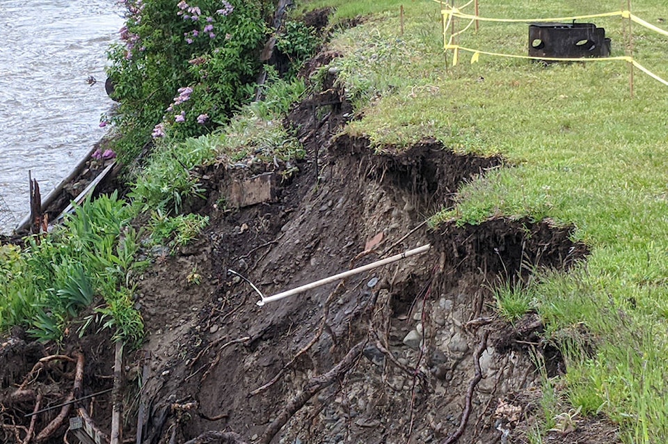
Two more Grand Forks properties in the Johnson Flats neighbourhood were issued evacuation alerts on May 27, after the Regional District of Kootenay Boundary (RDKB) determined that the eroded riverbank lining the properties could be susceptible to further damage, should river conditions worsen.
Current river forecasts show the Kettle River remaining at typical freshet level until Friday, then potentially rising to higher flood levels later over the weekend or into early next week, depending upon rainfall amounts and locations, an RDKB release said.
Temperatures throughout the Boundary are tracking well above seasonal averages, precipitating snowmelt in higher elevations. Possible rain over the weekend could cause significant spikes in river levels, the RDKB said.
Forecast graphs for the West Kettle and Kettle rivers at Westbridge (pulled May 28, 9:15 a.m.) indicate one-in-50-year discharge rates hitting that region between June 1 and 2.
The Granby River forecast for Grand Forks also shows a peak around that time that could be higher than 2018 levels, while the Kettle River forecast at Ferry, south of Midway, shows a peak of 18.5 feet around June 1, just slightly below that station’s crest on May 19.
In addition to the 19th Street properties, seven properties in Manly Meadows and seven properties in Johnson Flats also remain on evacuation alert due to risk of flooding.
The RDKB will provide more river updates before the weekend.
The EOC is currently at a Level 2 and will ramp up to a Level 3 if flood risks increase this weekend. The City of Grand Forks and the RDKB are also working together on operational pre-planning for flood protection of major infrastructure if required.
Sandbags and sand are currently available for residents in the following locations free of charge:
• Beaverdell behind the Fire Hall
• Westbridge Hall
• Riverside Centre in Rock Creek
• Grand Forks Arena
Residents must bring their own tools and equipment (shovels, transportation) and respect a physical distance of two metres (six feet) between workers as they fill sandbags.
For more information about snow and river levels as well as how to prepare for the 2020 freshet, visit emergency.rdkb.com. To register for the RDKB Emergency Alerting System go to https://ca.voyent-alert.com/vras/user-registration.html. The RDKB asks that people report any erosion or flooding to the Provincial Emergency Coordination Centre at 1-800-663-3456.