The Grand Forks/Christina Lake Multi-Use Trails project is a perfect example of what can happen when partners work together towards one common goal.
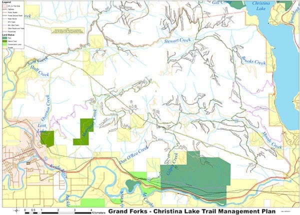
It has been the Grand Forks ATV Club at the helm, applying for and receiving a Job Creation grant to hire four people to clear, map, sign and install three staging areas in the Stewart, Morrissey and Sand Creek areas.
Two of the areas are now complete—Stewart and Morrissey—with work at Sand Creek underway.
In celebration of much work and planning, a special ribbon-cutting, trail opening and partner appreciation event will be held at Morrissey Creek staging area (one-half kilometre east of Grand Forks) on Wednesday, Oct. 15 at 1 p.m. Bring a chair.
The partners are a long list, ranging from the Boundary Horse Association to the Grand Forks Cycling Club to the Province of B.C.
“The Grand Forks ATV Club and the many partners are not establishing any new trails in their Grand Forks Christina Lake Multi-Use Trails Project,” explained Grand Forks ATV Club vice-president Doug Zorn. “We are using the trails and Forest Service roads that are existing.”
He added, “By being proactive we are helping the users by providing them information on the environment and wildlife in the area so they can make better choices when using the trails, and have a clear understanding of the sensitive species that call this area home.
“With signage everyone can safely enjoy the outdoors, have a great experience and with the staging areas locations have a picnic lunch or use a outhouse along the way.”
With volunteers assisting, the three staging areas are complete. Each has a toilet, picnic table, large kiosk, flat parking area, and an loading/unloading ramp.
The area covered by the multi-use project is from Grand Forks east to Christina Lake and Hwy 3 north to the Sand Creek Forest Service Road. This area encompasses land owned by several groups, including the City of Grand Forks, the Crown, the Nature Trust.
“The club had to create a Section 57, which lays out the area intended for use—what the use will be. This then goes to all tenors and government agencies that may have rights to the location,” Zorn said.
“Once all parties studied the Section 57 and commented, voicing their concerns, the applicant must address these concerns before being granted a permit.”
For the long-term, it is also imperative that all parties agree on several points, Zorn said: that all agree that the trails will be sustainable in nature and environmentally sensitive and reflect the values of the local community while respecting the values of non-trail users; that each party will respect the needs of individual requirements and work collectively; and that ultimately, it is collaboration, open communication, and integrity and respect that provide a foundation for the project.