Despite the public meetings held in Grand Forks and Christina Lake regarding the wildfires and the protocol regarding evacuations if it arises, the fires around the area have not grown significantly in the last few days. Currently, there have been no evacuation alerts or orders as of yet for Grand Forks and area.
There is a second public meeting regarding the Stickpin fire on Wednesday, Aug. 26 at Grand Forks at 6 p.m. at the high school and at Christina Lake at 8 p.m. at the community hall.
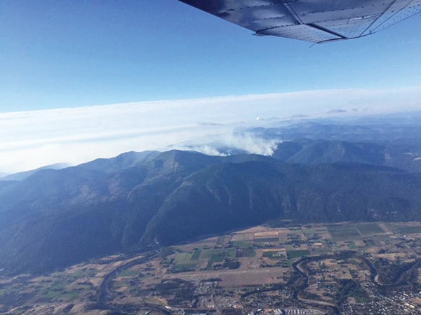
The Stickpin fire is now at 19,244 hectares (ha) and is 15 per cent contained.
Firelines on the western edge are holding. Crews continue to strengthen the lines. On the southern perimeter, dozer lines are being constructed but are indirect.
On Sunday, 33 BC wildfire service firefighters and three officers began fire suppression activities on the Stickpin wildfire in Washington State. They are responsible for Branch 3, also known as the Canadian branch, on the northeast portion of the fire. Objectives include developing situational and operational awareness for the first days on the fire, identifying fire lines and determining strategies and tactics moving forward.
On Monday, crews continued to create guard lines and fuel free areas on the northeast side of the fire, and began preparing for burn off operations along these lines. There was some minimal growth on the northwest side of the fire on Sunday. Crews made good progress towards containing this growth.
Smokey conditions in the area are limiting aircraft and ground crew operations.
The Stickpin fire is five kilometres from the Canadian border at its northern most point. Significant resources are being mobilized to Christina Lake in preparation should the winds push the fire to the northeast.
If required, BC Wildfire Service airtankers may use Christina Lake for air operations. An air attack officer flying in a smaller “bird-dog” or lead aircraft will sound an alarm over the area prior to the airtankers landing in the lake. For the safety of firefighting personnel and the public, recreational boaters are asked to avoid using the lake during these operations. Safe fire suppression efforts depend on the support and understanding of the public.
The BC Wildfire Service is working with structural protection firefighters from the Boundary region to assess properties which could potentially become threatened by this wildfire. Residents will be notified if an evacuation alert or order is put in effect.
The fire at Paulson Pass, approximately 15 kilometres northeast of Christina Lake, is at 300 Ha and is 80 per cent contained and crews continue to mop up on the western and north flanks. The fire remains highly visible from Highway 3.
The fire at Lynch Creek, 25 km north of Grand Forks, is at 250 Ha and is 10 per cent contains. Crews have been working on containment of the east flank. The fire is not threatening any structures or communities; however, smoke from the fire is visible to the residents in the North Fork area.
The Rock Creek wildfire is 75 per cent contained and is 4,534 Ha. The RDKB has completed an assessment of damage in the area and has confirmed that 30 homes and an additional 15 structures have been damaged or destroyed. There is an evacuation alert in effect. It has been downgraded from an evacuation order. The Ministry of Agriculture is working with farmers to restore internet services so supplies can be ordered for livestock. This area contains multiple potential hazards including active wildfires, “danger trees” (trees whose root systems have been weakened by fire activity), heavy equipment use and downed power lines. Entering any restricted area can delay firefighting activities, contribute to the growth of the fire and possibly put more values and people at risk. Safe risk suppression efforts depend on the support and understanding of the public.
The resiliency (Rock Creek evacuation) centre remains open in Midway at 692 7th Avenue.
Stickpin, Paulson and Lynch Creek are lightning-caused, while the Rock Creek fire is still under investigation but thought to be human-caused.
Smokey conditions are heavy throughout the Boundary. The smoke is originating from fires in Washington state.
All roads and highways are open. Check DriveBC.ca for current conditions.