It’s still a few months into the future, but all things being equal, there’s a reduced chance of river flooding this spring in the West Kootenay.
That’s the conclusion of river forecasters crunching the data on snowpack levels from this winter.
“February was relatively cold and dry in the mountains,” says Jonathan Boyd, a hydrologist at BC’s River Forecast Centre. The Centre issues monthly bulletins on the snowpack, and what might happen when that snow begins to melt in the spring.
This year, there’s just not as much snow at higher elevations compared to last year at this time, says Boyd.
“The snowpack as of March 1 is just slightly below normal, at 90 per cent of normal in the West Kootenay,” he says.
Boyd says that might come as a surprise to people who saw snowbanks growing exponentially in the valley bottoms last month, when several big storms hit the region.
“My friends and relatives say to me ‘the mountain snowpack must be unbelievable’,” he says. “But the conditions that lead to snowfall in the valley bottoms aren’t always the same as the conditions that lead to snowfall in the mountains.”
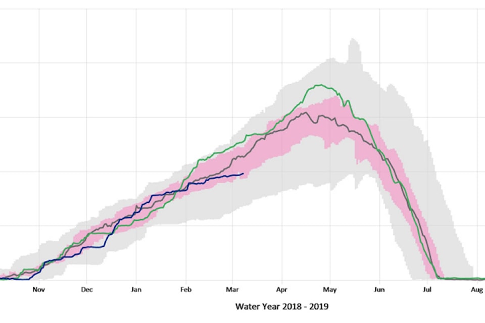
At this point last year, the snowpack in parts of the West Kootenay was 127 per cent of normal, compared to an average of about 90 per cent now. A station near Nelson is recording snowpack at high altitude at just 56 per cent of normal levels.
And Boyd says other parts of the province have seen the higher-elevation snowpack actually shrink.
Snow conditions and water supply bulletin
“The West Kootenays are one of the few basins that stayed about the same as from February 1st,” he says. “There was some snow accumulation there, but other areas saw no accumulation at all during the month.”
But Boyd cautions that just because the snowpack is down, that doesn’t mean there’s no chance of flooding. Weather during the freshet, or melt, can have a lot of impact on river levels.
“Even a normal or slightly below normal year can cause significant flooding if the perfect weather conditions lead up to it,” he says, pointing to what happened in Grand Forks last year as an example of a bad combination of weather and high water. “And a high snowpack year doesn’t necessarily mean flooding if the melt is gradual, and happens in waves.”
Boyd says it’s also still early in the year, and the Centre will be able to give more accurate, 10-day forecasts about the risk of flooding on West Kootenay rivers like the Slocan and Salmo in mid-April.
But he’s cautiously optimistic that the risk of flooding won’t be increased significantly by more snow.
“By March 1st, we typically see 80 per cent of the snow accumulation for the season,” he says. “So March and April can be about 20 per cent of the average snow occurring.
“We could still get slightly above-normal snowfall, but I just don’t think we can match the same level of snow as last year. It’s too late now, especially with a relatively dry start to March.”
reporter@rosslandnews.com
Like us on Facebook and follow us on Twitter